Image:Earthquake 20041226 epicentre.gif
From Wikipedia, the free encyclopedia
- Image
- File history
- File links
No higher resolution available.
Earthquake_20041226_epicentre.gif (499 × 496 pixel, file size: 25 KB, MIME type: image/gif)
|
|
This is a file from the Wikimedia Commons. The description on its description page there is shown below. |
|
|
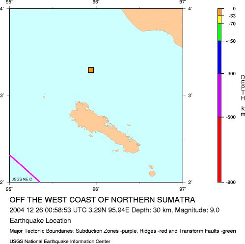
Epicenter of 2004 Indian Ocean earthquake, just north of Simeulue Island.
Note that although the epicenter of the earthquake was at this precise point source, about 1200 km of faultline slipped in total, in an arc curving northwards along the Nicobar Islands and Andaman Islands, and the resulting tsunamis were generated along this entire arc rather than from this point source.
Note the precise longitude and latitude shown in the caption have since been adjusted slightly by the USGS.
 |
This image is in the public domain because it contains materials that originally came from the United States Geological Survey, an agency of the United States Department of Interior. For more information, see the official USGS copyright policy |
|
Source
- http://neic.usgs.gov/neis/bulletin/neic_slav_l.html
- http://neic.usgs.gov/neis/bulletin/neic_slav_2.gif
File links
The following pages on the English Wikipedia link to this file (pages on other projects are not listed):
- 2004 Indian Ocean earthquake
- Simeulue