Image:Earthquake Information for Pakistan.gif
From Wikipedia, the free encyclopedia
- Image
- File history
- File links
No higher resolution available.
Earthquake_Information_for_Pakistan.gif (244 × 266 pixel, file size: 7 KB, MIME type: image/gif)
|
|
This is a file from the Wikimedia Commons. The description on its description page there is shown below. |
|
|
Summary
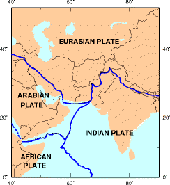
Earthquake information for Pakistan.
Licensing
 |
This image is in the public domain because it contains materials that originally came from the United States Geological Survey, an agency of the United States Department of Interior. For more information, see the official USGS copyright policy |
|
File links
The following pages on the English Wikipedia link to this file (pages on other projects are not listed):
- Geography of Pakistan
- South Asia
- Subcontinent
- Indian subcontinent
- Indian Plate
- Talk:Pakistan/Archive 6
- Tectonics zones of Pakistan
- 2005 Pakistan earthquake
Category: NPOV disputes