Image:Aral map.png
From Wikipedia, the free encyclopedia
- Image
- File history
- File links
No higher resolution available.
Aral_map.png (300 × 300 pixel, file size: 18 KB, MIME type: image/png)
|
|
This is a file from the Wikimedia Commons. The description on its description page there is shown below. |
|
|
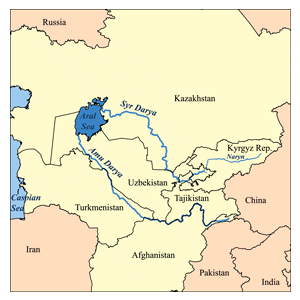
This is a map of area around the Aral Sea including the Amu Darya and Syr Darya rivers. I, Karl Musser, created it based on USGS data. The Aral Sea boundaries are circa 1960. Countries that are at least partially in the Aral Sea watershed are in yellow.
|
File links
The following pages on the English Wikipedia link to this file (pages on other projects are not listed):
- Amu Darya
- Aral Sea
- Syr Darya
- Transoxiana
- User:Kmusser/Images
Category: Maps of Turkmenistan