Image:LocationAngola.png
From Wikipedia, the free encyclopedia
- Image
- File history
- File links
No higher resolution available.
LocationAngola.png (250 × 115 pixel, file size: 6 KB, MIME type: image/png)
|
|
This is a file from the Wikimedia Commons. The description on its description page there is shown below. |
|
|
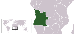
Location map for the Angola.
Originally created for English Wikipedia by Vardion.
 |
This image has been released into the public domain by its author, Vardion. This applies worldwide. In some countries this may not be legally possible; if so: |
|
English | Français | +/- |
|
 A vector version of this image ("SVG") is available. For more information about vector graphics, read about Commons transition to SVG. English | Français | Polski | +/- |
 |
File links
The following pages on the English Wikipedia link to this file (pages on other projects are not listed):
- User:DanielZM/test
Category: Maps of Angola