Image:LocationUruguay.png
From Wikipedia, the free encyclopedia
- Image
- File history
- File links
No higher resolution available.
LocationUruguay.png (250 × 115 pixel, file size: 5 KB, MIME type: image/png)
|
|
This is a file from the Wikimedia Commons. The description on its description page there is shown below. |
|
|
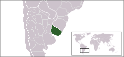
Location map for the Uruguay.
Originally created for English Wikipedia by Vardion.
 |
This image has been (or is hereby) released into the public domain by its author, Vardion at the English Wikipedia project. This applies worldwide. In case this is not legally possible: |
 A vector version of this image ("SVG") is available. For more information about vector graphics, read about Commons transition to SVG. English | Français | Polski | +/- |
 |
File links
The following pages on the English Wikipedia link to this file (pages on other projects are not listed):
- User:DanielZM/test
- User:Gustavo Szwedowski de Korwin
- Wikipedia:WikiProject Uruguay/uysidebar
- Portal:Uruguay
- Portal:Uruguay/Intro