Image:Trnc-map.gif
From Wikipedia, the free encyclopedia
- Image
- File history
- File links
No higher resolution available.
Trnc-map.gif (508 × 300 pixel, file size: 10 KB, MIME type: image/gif)
|
|
This is a file from the Wikimedia Commons. The description on its description page there is shown below. |
|
|
 |
This map has been uploaded by Electionworld from en.wikipedia.org to enable the |
 |
The copyright holder of this image allows anyone to use it for any purpose including unrestricted redistribution, commercial use, and modification. Note: العربية | Česky | Dansk | Deutsch | English | Esperanto | Español | فارسی | Français | Italiano | 日本語 | 한국어 | Kurdî / كوردي | Nederlands | Polski | Português | Русский | Svenska | Türkçe | 简体中文 | 正體中文 | 粵語 | +/- |
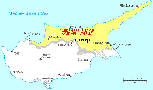
Map showing the Turkish Republic of Northern Cyprus (in yellow). The tiny exclave is called Erenköy.
File links
The following pages on the English Wikipedia link to this file (pages on other projects are not listed):
- Turkish Republic of Northern Cyprus
- User:Mitsos
- User:Kyriakos/Userboxes