Image:Su-map.png
From Wikipedia, the free encyclopedia
- Image
- File history
- File links
No higher resolution available.
Su-map.png (327 × 350 pixel, file size: 13 KB, MIME type: image/png)
|
|
This is a file from the Wikimedia Commons. The description on its description page there is shown below. |
|
|
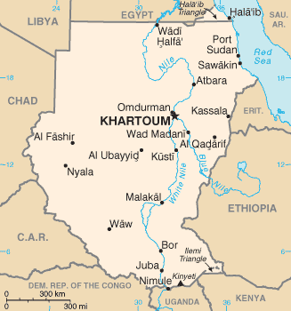
CIA map of Sudan
 |
This image is in the public domain because it contains materials that originally came from the United States Central Intelligence Agency's World Factbook. |
 |
File links
The following pages on the English Wikipedia link to this file (pages on other projects are not listed):
- 1884
- Equatoria
- South Darfur
- South Kurdufan
- North Darfur
- North Kurdufan
- Bahr el Ghazal
- Kurdufan
- Al-Ubayyid
- Kutum
- List of Sudanese
- Image:Sudan map narrow.gif