Image:ColonialAfrica.png
From Wikipedia, the free encyclopedia
ColonialAfrica.png (293 × 334 pixel, file size: 8 KB, MIME type: image/png)
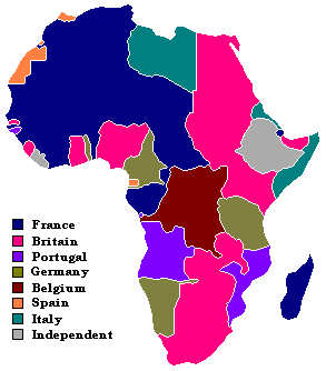
Map showing European claimants to the African continent in 1913
Turned Image:Colafrica.jpg of User:J.J. into png which is a more proper format for this.

Permission is granted to copy, distribute and/or modify this document under the terms of the GNU Free Documentation License, Version 1.2 or any later version published by the Free Software Foundation; with no Invariant Sections, no Front-Cover Texts, and no Back-Cover Texts.
Subject to disclaimers.
File history
Legend: (cur) = this is the current file, (del) = delete this old version, (rev) = revert to this old version.
Click on date to download the file or see the image uploaded on that date.
- (del) (cur) 20:36, 16 December 2006 . . Albrecht ( Talk | contribs) . . 293×334 (8,592 bytes) (Reverted to earlier revision)
- (del) (rev) 17:27, 12 December 2006 . . Beornas ( Talk | contribs) . . 293×334 (8,479 bytes) (Edit colors)
- (del) (rev) 05:06, 13 October 2006 . . Albrecht ( Talk | contribs) . . 293×334 (8,592 bytes) (Reverted to earlier revision)
- (del) (rev) 04:18, 13 October 2006 . . ArchonMeld ( Talk | contribs) . . 324×362 (9,062 bytes) (I simply have changed to colors of a previous uploaded self-made and publicly released image to colors that are easier to recognize with the imperial powers they represent rather than arbitrary pinks and purples. )
- (del) (rev) 07:58, 19 May 2006 . . SouthEastLad ( Talk | contribs) . . 293×334 (8,592 bytes) (Reverted to earlier revision)
- (del) (rev) 07:58, 19 May 2006 . . SouthEastLad ( Talk | contribs) . . 509×571 (24,087 bytes) (Reverted to earlier revision)
- (del) (rev) 05:18, 16 May 2006 . . Albrecht ( Talk | contribs) . . 293×334 (8,592 bytes) (Small adjustments to conform to 1913 date.)
- (del) (rev) 17:18, 15 May 2006 . . Albrecht ( Talk | contribs) . . 293×334 (8,466 bytes) (Upload in standard map format; fix many errors.)
- (del) (rev) 16:59, 7 April 2006 . . Naddy ( Talk | contribs) . . 509×571 (10,540 bytes) (typo)
- (del) (rev) 22:44, 9 March 2006 . . Dwiki ( Talk | contribs) . . 509×571 (24,087 bytes) (okay, one more try...)
- (del) (rev) 22:42, 9 March 2006 . . Dwiki ( Talk | contribs) . . 529×589 (25,553 bytes) (oops, now it's updated.)
- (del) (rev) 22:41, 9 March 2006 . . Dwiki ( Talk | contribs) . . 529×589 (25,553 bytes) (Cleaned up image quality)
- (del) (rev) 08:56, 19 February 2006 . . Aleksei ( Talk | contribs) . . 529×589 (20,599 bytes) (Added Independent)
- (del) (rev) 07:54, 17 February 2006 . . Aleksei ( Talk | contribs) . . 529×589 (20,063 bytes) (Reverted to earlier revision)
- (del) (rev) 07:52, 17 February 2006 . . Aleksei ( Talk | contribs) . . 276×323 (11,857 bytes) (Reverted to earlier revision)
- (del) (rev) 07:50, 17 February 2006 . . Aleksei ( Talk | contribs) . . 529×589 (20,063 bytes) (Reverted to earlier revision)
- (del) (rev) 07:48, 17 February 2006 . . Aleksei ( Talk | contribs) . . 529×589 (20,063 bytes) (Old version didn't work.)
- (del) (rev) 07:45, 17 February 2006 . . Aleksei ( Talk | contribs) . . 529×589 (20,063 bytes) (Made it myself from BlankMap-World.png. Added Hala'ib Triangle, Cape Verde, Seychelles, São Tomé and Príncipe, Bioko.)
- (del) (rev) 06:36, 17 February 2006 . . Makaristos ( Talk | contribs) . . 276×323 (11,857 bytes) (Reverted to earlier revision)
- (del) (rev) 18:41, 22 October 2005 . . Giddylake ( Talk | contribs) . . 276×323 (11,365 bytes) (Reverted to earlier revision)
- (del) (rev) 18:41, 22 October 2005 . . Giddylake ( Talk | contribs) . . 276×323 (11,378 bytes) (Reverted to earlier revision)
- (del) (rev) 01:15, 23 September 2005 . . Andrew Levine ( Talk | contribs) . . 276×323 (11,857 bytes) (Altered colour scheme so that there are no longer three competing shades of orange)
- (del) (rev) 11:37, 21 August 2005 . . Cwoyte ( Talk | contribs) . . 276×323 (11,365 bytes) ((Small border corrections for Spanish Sahara/Morocco; Togoland/ Gold Coast, and Libya/ Anglo-Egyptian Sudan/Egypt.) )
- (del) (rev) 17:08, 19 August 2005 . . Cwoyte ( Talk | contribs) . . 276×323 (11,378 bytes) (Small border corrections for Spanish Sahara/Morocco; Togoland/ Gold Coast, and Libya/ Anglo-Egyptian Sudan/Egypt.)
- (del) (rev) 19:21, 26 July 2005 . . Huhsunqu ( Talk | contribs) . . 276×323 (8,298 bytes)
- (del) (rev) 21:37, 10 October 2004 . . SimonP ( Talk | contribs) . . 276×323 (7,068 bytes) (tweaks)
- (del) (rev) 19:01, 10 October 2004 . . SimonP ( Talk | contribs) . . 276×323 (7,219 bytes) (coorect and error)
- (del) (rev) 10:00, 15 August 2004 . . Aris Katsaris ( Talk | contribs) . . 276×347 (8,476 bytes) (Turned Image:Colafrica.jpg of User:J.J. into png which is a more proper format for this.)
-
Edit this file using an external application
See the setup instructions for more information.
File links
- History of Western Sahara
- Economy of Africa
- Maafa
- User:Blackpower
- Africa
Categories: GFDL images | Maps of the history of Africa