Image:Scotland map.png
From Wikipedia, the free encyclopedia
- Image
- File history
- File links
No higher resolution available.
Scotland_map.png (253 × 372 pixel, file size: 30 KB, MIME type: image/png)
|
|
This is a file from the Wikimedia Commons. The description on its description page there is shown below. |
|
|
 |
This map has been uploaded by Electionworld from en.wikipedia.org to enable the |
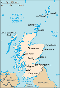
Modified CIA-sourced map of Scotland
 |
This image is in the public domain because it contains materials that originally came from the United States Central Intelligence Agency's World Factbook. |
 |
File links
The following pages on the English Wikipedia link to this file (pages on other projects are not listed):
- Scotland
- Scotland in the Wars of the Three Kingdoms
- Geography of Scotland
- User:Mgekelly/Where
- User:Andy mci
- User:Ben MacDui/Scotland/Geography redraft