Image:Stpierremap.png
From Wikipedia, the free encyclopedia
- Image
- File history
- File links
No higher resolution available.
Stpierremap.png (300 × 299 pixel, file size: 16 KB, MIME type: image/png)
|
|
This is a file from the Wikimedia Commons. The description on its description page there is shown below. |
|
|
Summary
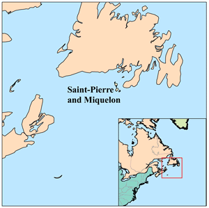
This is a locator map of Saint-Pierre and Miquelon that I made using the Digital Chart of the World.
Licensing
|
File links
The following pages on the English Wikipedia link to this file (pages on other projects are not listed):
- Saint Pierre and Miquelon
- User:Kmusser/Images
- User:TheGrappler/North America directory
Category: Maps of Saint-Pierre and Miquelon