Image:CIA-Dhekelia.png
From Wikipedia, the free encyclopedia
CIA-Dhekelia.png (329 × 353 pixel, file size: 29 KB, MIME type: image/png)
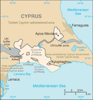
World Factbook map of Dhekelia SBA. From http://www.odci.gov/cia/publications/factbook/geos/dx.html
|
|
This image is a map or flag taken and/or modified from the Central Intelligence Agency's World Factbook. Under United States copyright law, all information and images from the World Factbook are in the public domain |
File history
Legend: (cur) = this is the current file, (del) = delete this old version, (rev) = revert to this old version.
Click on date to download the file or see the image uploaded on that date.
- (del) (cur) 05:25, 25 December 2004 . . Hoshie ( Talk | contribs) . . 329×353 (29,835 bytes) (Update of the CIA map as of 16 Dec 04)
- (del) (rev) 16:20, 12 December 2004 . . Eugene van der Pijll ( Talk | contribs) . . 329×351 (10,381 bytes) (Corrected labeling of Greek/Turkish Cyprus)
- (del) (rev) 04:32, 4 December 2004 . . Hoshie ( Talk | contribs) . . 329×351 (10,823 bytes) (World Factbook map of Dhekelia SBA. From http://www.odci.gov/cia/publications/factbook/geos/dx.html)
-
Edit this file using an external application
See the setup instructions for more information.
File links
- Akrotiri and Dhekelia
- Ayia Napa
Categories: CIA World Factbook images | Maps of Akrotiri and Dhekelia