Image:Cyprus SBAsInRed.png
From Wikipedia, the free encyclopedia
- Image
- File history
- File links
No higher resolution available.
Cyprus_SBAsInRed.png (630 × 321 pixel, file size: 27 KB, MIME type: image/png)
|
|
This is a file from the Wikimedia Commons. The description on its description page there is shown below. |
|
|
Summary
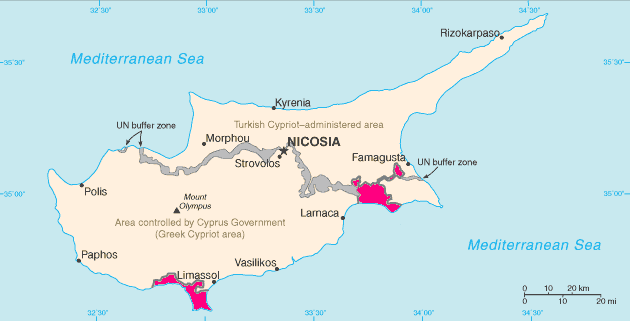
Español: Situación de Acrotiri (en el sur) y Dhekelia (en el este)
en: Map of Cyprus with WSBA and ESBA in pink, the traditional colour on maps for British possessions. The map is adapted from the CIA World Factbook map.
ru: Территории Акротири и Декелии выделены красным цветом.
 |
This image is in the public domain because it contains materials that originally came from the United States Central Intelligence Agency's World Factbook. |
 |
Uploaded 14:03, 1 May 2005 by Hoshie
File links
The following pages on the English Wikipedia link to this file (pages on other projects are not listed):
- Sovereign Base Areas
- Akrotiri and Dhekelia
- British Forces Cyprus
- User:Hoshie/Images
- User:TheGrappler/Europe directory
- Languages of Akrotiri and Dhekelia
Category: Maps of Akrotiri and Dhekelia