Tehran
2007 Schools Wikipedia Selection. Related subjects: Geography of the Middle East
| تهران Tehran |
|
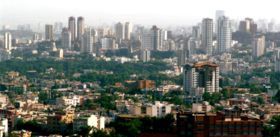
| View from Jamaran looking southwest toward Elahiyeh, Jordan, and Shemiran districts of Tehran. | |
| Nickname: "The city of 72 nations." | |
| Coordinates: | |
|---|---|
| Mayor | Mohammad Ghalibaf |
| Area | |
| - City | 1500 km² (579 sq mi) |
| - Urban | 686 km² (265 sq mi) |
| - Metro | 18,814 km² (7,264 sq mi) |
| Elevation | 1200 m (3900 ft) |
| Population | |
| - City (est.) | 7,314,000 |
| - Density | 10,000/km² |
| - Metro | 12,150,742 |
| Data refers to Tehran Province | |
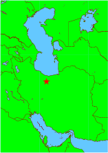
Tehran ( IPA: [tʰehˈɾɒn]; Persian: تهران, also transliterated as Teheran or Tehrān), population (as of 2005) 7,314,000 (metropolitan: 12,151,000), and a land area of 658 square kilometers, is the capital city of Iran ( Persia) and the centre of Tehran Province.
More than half of the country's industry is based there. Industries include the manufacturing of automobiles, electronics and electrical equipment, military weaponry, textiles, sugar, cement, and chemical products. It is also a leading centre for the sale of carpets and furniture. There is an oil refinery nearby.
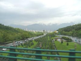
Tehran is a sprawling city at the foot of the Alborz mountain range with an immense network of highways unparalleled in western Asia. It is also the hub of the country's railway network. The city has numerous large museums, art centers, palace complexes and cultural centers.
In addition to Persians, there is a large population of Azeris in Tehran, as well as other ethnicities including Armenian, Assyrian, Kurdish, Jewish and Zoroastrian communities. The majority of Tehran's residents speak Persian. The city is dotted with mosques, churches, synagogues and Zoroastrian fire temples.
Etymology
There are various theories pertaining to the origin of the name Tehran. One plausible theory is that the word "Tehran" is derived from Tiran/Tirgan, "The Abode of Tir" (Tir being the Zoroastrian deity equivalent to the Greek deity Mercury). The ancient Parthian town of Tiran was a neighbour to the town of Mehran ("The Abode of Mehr/Mithra", the Zoroastrian sun god). Both of these were mere villages in the suburbs of the great city of Ray/Rhages. Mehran is still extant and forms a residential district inside the Greater Tehran, as is also Ray—which forms the southern suburbs of Tehran.
Another theory is that Tehran means "a warm place", as opposed to "a cool place" (e.g. Shemiran)—a cooler district in northern Tehran. Some current texts in this regard claim that the word Tehran in Persian means "warm mountain slope" (دامنه گرم).
The official City of Tehran website says that "Tehran" comes from the Persian words "Tah" meaning "end or bottom" and "Ran" meaning "[mountain] slope"—literally, bottom of the mountain slope. Given Tehran's geographic position at the bottom of the slope of the Alborz Mountains, this appears to be the most plausible explanation of the origin of the name of the city (دامنه ی بین دو کوه).
History
Excavations place the existence of settlements in Tehran as far back as 6000 BC. Tehran was well known as a village in the 9th century, but was less well-known than the city of Rhages which was flourishing nearby in the pre- Mongol era. In the 13th century, following the destruction of Ray by Mongols, many of its inhabitants fled to Tehran. In some sources of the Mongol era the city is mentioned as "Rhages's Tehran" (طهرانِ ری). The city is later mentioned in Hamdollah Mostowfi's Nuz'hat al-Qulub (written in 1340) as a famous village.
Don Ruy Gonzáles de Clavijo, a Castilian ambassador, was probably the first European to visit Tehran, stopping in July 1404, while on a journey to Samarkand (now in Uzbekistan) and the Mongol capital at the time. At this time, the city of Tehran was unwalled.
Tehran became a residence of the Safavid rulers in the 17th century. Tahmasp I built a bazaar and a wall around the city, but it somewhat fell out of favour after Abbas I turned sick when he was passing the city to go to a war with the Uzbeks.
In the early 18th century, Karim Khan Zand ordered a palace, a harem, and a government office to be built in Tehran, possibly to declare the city his capital, but later moved his government to Shiraz. Tehran finally became the capital of Persia in 1795, when the Qajar king Agha Mohammad Khan was crowned in the city. It remains the capital to this day.
During World War II, British and Soviet troops entered the city. Tehran was the site of the Teheran Conference in 1943, attended by U.S. President Franklin D. Roosevelt, British Prime Minister Winston Churchill, and Soviet Premier Joseph Stalin.
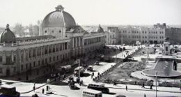
Following the war, the city's older landmarks suffered under the rule of Mohammad Reza Shah. The Shah believed that ancient buildings such as large parts of the Golestan Palace, Takieh-ye Dowlat, the Toopkhooneh Square (pictured to the right), and others should not be part of a modern city. They were systematically destroyed and modern 1950s and 1960s buildings were built in their place. The decision to carry this out is presently largely seen as a foolish mistake that hurt the visual fabric of the city beyond repair.
On September 8, 1978, demonstrations against the Shah led to riots. The army reportedly opened fire on the demonstrating mob. Martial law was installed in the wake of the ensuing revolution, from 1978–79.
During the 1980–88 Iran-Iraq War, Tehran was the scene of repeated Scud missile attacks and air strikes against random residential and industrial targets within the city, resulting in thousands of civilian casualties. Material damage was repaired soon after each strike.
Modern Tehran
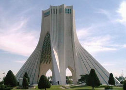
The Azadi Tower is the first landmark visitors come across when arriving from the Mehrabad International Airport. The tower has become an icon for Tehran and a national symbol of Iran.
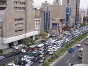
Tehran suffers from extremely serious traffic congestion and pollution problems. Respiratory ailments such as asthma are very common. Tehran has become so congested over the past decade that the government has considered moving the nation's capital to another city to alleviate these problems and help de-centralize the economy and population. But because Iran's economy and politics are so centralized, millions have little choice but to live and work in Tehran.
The Peacock Throne of the Persian Shahs can be found in Tehran's Golestan Palace. Some of the important museums are National Museum of Iran, Sa'dabad Palaces Complex, Glassware and Ceramics Museum of Iran, The Carpet Museum of Iran, Tehran's Underglass painting Museum, and Niavaran Palace Complex. The Tehran Museum of Contemporary Art is also appealing to many because it features the works of great artists such as Van Gogh, Pablo Picasso and Andy Warhol.
The huge Tehran International Fair organises many expositions. Its book expositions are especially popular. Tehran is also the seat of Iran's Parliament (the Majles). And Tehran is also home to the world's fourth tallest free standing structure, the Milad Tower.
The Milad Complex
The Tehran International Trade and Convention Centre, also called The Milad Complex, is one of the largest structures in Iranian architecture. It is scheduled to be finished in late 2007. The complex contains the world's 4th highest tower which has several restaurants, a five star hotel, a convention center, a world trade centre, and an IT park (to be completed by March 2007). The complex seeks to respond to the needs of business in the globalized world of the 21st century by offering facilities combining trade, information, communication, convention and accommodation all in one place. The Milad Tower is predicted to replace the long-time symbol of Tehran, the Azadi Tower.
Location and Subdivisions
Tehran county borders Shemiranat county to the north, Damavand county to the east, Eslamshahr, Pakdasht, and Ray counties to the south, and Karaj and Shahriar counties to the west.
Neighborhoods and Districts of Tehran
The city of Tehran is divided into 22 municipal districts, each with its own administrative centers. Within these 22 districts, Tehran contains the following major neighborhoods :
Abbas Abad, Afsariyeh, Amir Abad, Bagh Feiz, Baharestan, Darakeh, Darband, Dardasht, Dar Abad, Darrous, Dehkadeh Olampik, Ekhtiyariyeh, Elahiyeh, Evin, Farmanieh, Gheitariye, Gholhak, Gisha, Gomrok, Hasan Abad, Jamaran, Jannat Abad, Javadiyeh, Jomhuri, Jordan, Narmak, Navvab, Nazi Abad, Niavaran, Park-e Shahr, Pasdaran, Punak, Ray, Sa'adat Abad, Sadeghiyeh, Shahrara, Shahr-e ziba, Shahrak-e Gharb, Shemiran, Tajrish, Tehranpars, Vanak, Velenjak, Yaft Abad, Yusef Abad, Zafaraniyeh, etc.
For the full list, see List of the localities around Tehran.
The older neighborhoods of Tehran
Tehran's old city fabric changed dramatically during the Pahlavi era. Some of the older remaining districts of Tehran are: Udlajan, Sangelaj, Bazaar, Chaleh Meydan, Doulat. Chaleh Meydan is the oldest neighbourhood of the aforementioned.
Economy
About 30% of Iran’s public-sector workforce and 45% of large industrial firms are located in Tehran and almost half of these workers work for the government. Most of the remainder of workers are factory workers, shopkeepers, labourers, and transport workers. Few foreign companies operate in Tehran because of the Islamic government and its poor relations with the west. But before the Islamic revolution many western companies were active in this region. Today many modern industries of this city include the manufacturing of automobiles, electronics and electrical equipment, weaponry, textiles, sugar, cement, and chemical products. It is also a leading centre for the sale of carpets and furniture. There is an oil refinery nearby. The city has two airports, including Mehrabad International Airport, and Imam Khomeini International Airport. Tehran relies heavily on private cars, buses, motorcycles, and taxis, and is one of the most car-dependent cities in the world. The Tehran Stock Exchange, which is a full member of the Federation Internationale des Bourses de Valeurs (FIBV) and a founding member of the Federation of Euro-Asian Stock Exchanges, was one of the world's best performing stock exchanges in recent years. .
Transport
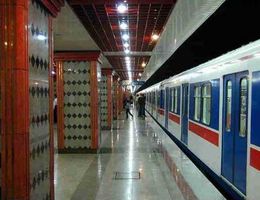
In 2001 a metro system that had been in planning since the 1970s opened the first two of seven envisaged lines -- even though the city is prone to earthquakes. Work has been slow and coverage remains very limited. Development of the Tehran metro system had been interrupted by the Islamic Revolution and the Iran-Iraq War. Problems arising from the late completion of the metro led to buses taking on the role of the metro lines, serving mainly long distance routes. Taxis filled the void for local journeys. The taxis only drive on main roads, and only within the local area, so it can be necessary to take several taxis to get to one's final destination. This has all led to extreme congestion and air pollution within the city.
Tehran is served by Mehrabad International Airport, the old airport which doubles as a military base located in the western part of the city, and Imam Khomeini International Airport, 50 kilometers south, which handles flights from the Persian Gulf but which will eventually handle all international flights. The new airport is more than overdue, but is efficient, although security concerns have made the governments of Britain and Australia warn their foreign nationals in Iran.
Tehran also has a central train station with connecting services round the clock to various cities in the country. There are four bus terminals that also provide connections at low fares. These are the South, East, West, and Bei-haghi Park-Drive Terminals.
While the centre of the city houses the government ministries and headquarters, the commercial centers are more located toward Valiasr Street, Taleghani Ave, and Beheshti Ave. further north. Although administratively separate, Rey, Shemiran, and Karaj are often considered part of the larger Tehran metropolitan area.
See also: List of Tehran metro stations, Tehran Monorail.
Pollution
Tehran, like many big cities, suffers from severe air pollution and the city is often covered by smog making breathing difficult and causing widespread pulmonary illnesses. It is estimated that about 27 people die each day from pollution-related diseases.
The air pollution is due to several different reasons: 1) Economical: most Iranian industries are located on the outskirts of Tehran. The city is also overrun with old and aging cars which do not meet today's emission regulations. Furthermore, Iran's busiest airport, Mehrabad International Airport, is located in the west of the city; 2) Infrastructure: Tehran has a poor public transportation network. Buses and metros do not cover every area of the city. Most people are then obliged to either use private cars or hire taxis. This has created severe traffic and congestion; 3) Geographical: Tehran is bound in the north by the massive Alborz mountain range that is stopping the flow of the humid Caspian wind. As a result, thermal inversion that traps Tehran's polluted air is frequently observed. The lack of humidity and clouds makes Tehran a very sunny city. The UV radiations then combined with the existing pollutants significantly raise the level of the ozone.
The government, however, is engaged in a battle to reduce the air pollution. It has for instance encouraged taxis and buses to convert from petrol engines to engines that run on compressed natural gas. Furthermore, since 1979 the government of the Islamic Republic of Iran has setup a "Traffic Zone" (طرح ترافیک) covering the city centre during peak traffic hours. Entering and driving inside this zone is only allowed with a special permit. The government is also trying to raise people's awareness about the hazards of the pollution. One method that is currently been employed is the installation of Pollution Indicator Boards all around the city to monitor the current level of particulate matter (PM10), nitrogen dioxide (NO2), ozone (O3), sulfur dioxide (SO2), and carbon monoxide (CO). The board also displays the Pollutant Standard Index (PSI), which is a general indication of air quality based on the measurements of the above-mentioned five pollutants. The Pollution Indicator Boards classify the level of each pollutants as either safe, hazardous or dangerous.
Research and education
Ever since the establishment of Darolfonoon in the mid 1800s, Tehran has amassed an abundance of institutions of higher education. Some of these institutions have played crucial roles in the unfolding of Iranian political events. Tehran University is the earliest state university and the largest university of Iran. Samuel M. Jordan, whom "Jordan Avenue" in Tehran is named after, was also one of the founding pioneers of the American College of Tehran. Today There are nearly 50 major colleges and universities in total in Greater Tehran, listed below:
|
|
Tehran also contains Iran's largest military academy, and several religious schools and seminaries. See List of colleges and universities in Tehran for a more comprehensive listing.
Sport
Tehran was the first city in the Middle East to host the Asian Games. The 7th Asian Summer Games in 1974, was held with the participation of 2,363 athletes and officials from 25 countries.
Tehran is also the site of Iran's national football stadium on Azadi Sport Complex with 100,000 seating capacity. Many of the top matches of Iran's Premier League are held here. In 2005, FIFA ordered Iran to limit spectators allowed into Azadi stadium because of a fatal crush and inadequate safety procedures. Other stadiums in Tehran are Shahid Dastgerdi Stadium, Takhti Stadium, and Shahid Shirudi Stadium, among others.
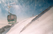
Within 10 minutes of driving distance from Tehran lies a ski resort. Tochal is the world's fifth highest ski resort at over 3730m at its highest 7th station. The resort was completed in 1976 shortly before the overthrow of the Shah.
Here, one must first ride the eight km (five mile) long gondola lift which covers a huge vertical. The 7th station has three slopes. The resort's longest slope is the south side U shaped slope which goes from the 7th station to 5th station. The other two slopes are located on the north side of the 7th station. Here, there are two parallel chair ski lifts that go up to 3900m near Tochal's peak (at 4000m), rising higher than the gondola 7th station. This altitude is higher than any of the European resorts.
From the Tochal peak, one has a spectacular view of the Alborz range, including the 5671 metre (18606 ft) high Mt. Damavand, a dormant volcano.
At the bottom of the lifts in a valley behind the Tochal peak is Tochal hotel, located at 3500m altitude. From there a T lift takes skiers up the 3800 metres of Shahneshin peak, where the third slope of Tochal is.
Tochal 7th station has skiing eight months of the year. But there are also some glaciers and year-round snow fields near Tehran where skiing began in 1938, thanks to the efforts of two German railway engineers. Today, 12 ski resorts operate in Iran, but the most famous are Tochal, Dizin, and Shemshak, all within one to three hours of Tehran.
Football
In football (soccer), Tehran is host to seven football clubs in Iran's Premier Football League, namely:
|
|
These clubs have on numerous occasions won Asian titles, and some of their players are known internationally. The prominent matches are usually held at Azadi stadium.
Outdoors
- Tochal Ski resort
- Darband hiking trail
- Chitgar Park
- Mellat Park
- Laleh Park
- Jamshidieh Park
- Niavaran Park
- Sa'ei Park
- Daneshju Park
- Shahr-e Bazi amusement park.
- Shatranj Park
- Darabad hiking trail
- Darakeh hiking trail
- Jahan-e Kudak Park
- Azadi Sports complex
- Enghelab Sports Complex and Golf course
- Several caves, springs, and waterfalls outisde Tehran.
- Latyan Lake
- Lavizan Forest Park
- Vardavard Forest Park
- Khajeer National Park
- Kavir National Park
- Tar Lake
- Amir Kabir Lake
- Lar Protected Natural Habitat
- Varjeen Protected Natural Habitat
- Pardisan
- Tangeh Savashi
- Shahr-e Bazi
Images of Tehran
Landmarks
|
AzaImagedi1.jpg
Azadi Tower, Azadi Square. |
|||
Its culture
Its nature and life
|
Tehran's winter |
|||
Culture and attractions
Tehran, as Iran's showcase and historical capital city, has a wealth of cultural attractions, some of which are listed below.
| Cultural Attractions of Tehran | |
|---|---|
| Palaces | Golestan Palace and Takht-e Marmar, Niavaran Palace Complex, Sadabad Palace, Saltanat Abad Palace, Firouzeh Palace, Soleymaniyeh Palace, Baharestan Palace, Morvarid Palace, The new Majlis |
| Museums | Sa'd Abad Gallery of Fine Arts, Glassware Museum of Tehran, Iran's National Rug Gallery, Reza Abbasi Museum, Tehran Museum of Contemporary Art, Tehran Theatre of the Performing Arts, Talar Vahdat Theatre, National Museum of Iran, Dar-abad Nature & Wildlife Museum, National Library of Iran, Malek National Library, National Car Museum of Iran |
| Castles and Forts | Arzhang fort in Taleqan, Iraj Fort in Varamin, Gol e Khandan Fort in Rudehen from Sassanid era, Rashkan Fort in Ray from Parthian era, Tabbarok Fort from Abbasid era, Sorkheh-Hesar Fort from Seljuqi era, Kei-Qobad Fort in Taleqan from Ismaili era, Gabri Fort from Parthian era in Ray, Ghal'eh Dokhtar Tang Goseel near Karaj from Seljuqi era, Harun Prison from Sassanid era, Bagh e Melli foreign ministry compounds. |
| Famous Houses | Etehadiyeh House ( Qajar era), Amir Bahador House ( Qajar era), Emam Jom'eh House (1863CE), Amin ol-Soltan House (Qajar era), Shaqāqi (Kushak) House ( Qajar era), Emārat e Bagh e Ferdows (Qajar era), Emārat Farmaniyeh ( Qajarid era), Shahid Modarres House, Vothuq House (1837CE), Moshir o-Dowleh Pir Nia House, House of Nima Yooshij, House of Mohammed Mossadegh, House of Ayatollah Taleghani, House of Ghavam o-Dowleh, House of Imam Khomeini, House of Mahmoud Hessaby. |
| Archeological sites | Cheshme Ali Teppe (5th millennium BCE) excavated by Jacques de Morgan, Shoghali Teppe (6th millennium BCE), Qeytariyeh Cemetery (2nd millennium BCE), Teppe Meel (excavated by Jacques de Morgan) believed to be the temple of the legendary ancient leader Bahram Gur, Vavan Teppe of Sassanid era, Ghareh Teppe (6th millennium CE) excavated by the British Burton Brown, Ozbaki Teppe in Hashtgerd |
| Others | Iran National Library, The Milad Tower, Darolfonoon, Morvarid Canon of the Afsharid dynasty era, Tughrul Tower of Seljuqi era, Tehran's Grand Bazaar (1523CE), Pol e Rumi from the Safavid era (today a property of the Embassy of Turkey), Alborz High School, Firouz Bahram High School, Stodan Of Zoroastrian located in Aminabad area. |
Religious centers
- Hosseiniye Ershad
- Soltani Mosque, built by Fath Ali Shah
- Atiq Mosque, built in 1663.
- Mo'ezz o-dowleh mosque, built by Fath Ali Shah
- Haj Seyd Azizollah mosque, built by Fath Ali Shah
- Al-javad mosque, Iran's first modernist design mosque.
- The Old Sepahsalar mosque, another prominent Qajar era mosque.
- The new Sepahsalar mosque (Madreseh e Motahari)
- Filsuf o-dowleh Mosque, Qajar era
- Moshir ol-Saltaneh Mosque, Qajar era
- Mo'ayyer ol-Mamalik Mosque, Qajar era
- Shahr Banu Mausoleum
- Javan-mard Qassab Mausoleum, a pre-Islamic semi-mythical hero
- Dozens of Imam-zadeh shrines, hundreds of years old, including that of Imam Zadeh Saleh.
- Dozens of Saqa Khanehs: traditional places of prayer
- Several Tekyehs: traditional places for mourning Muharram ceremonies for Husayn ibn Ali.
- Ibn Babviyeh cemetery, where many Iranian giants such as Takhti and Ali Akbar Dehkhoda are buried.
- Zahir o-dowleh cemetery, where many Iranian giants of art and culture such as Iraj Mirza, Mohammad Taghi Bahar, Forough Farrokhzad, Abolhasan Saba, Ruhollah Khaleghi, and Darvish-khan are buried.
- Kordan Tomb, Seljuqi era, Karaj.
- Maydanak Tomb, 13th century, Karaj
- The Polish Cemetery 1-north of Tehran in British Gholhak Garden, where numerous World War II western Allied soldiers are buried. 2- Polish cemetery (Catholic cemetery) Dulab south of Tehran
- Orthodox Cemetery, Dulab/The Russian Unknown Soldier's Tomb (Cenotaph) is located here with a red star over it
- Tower of silence (Dakhme gabrha). Located on Moshiryh Road behind 7th unit of Tehran cement factory. It is circular in shape.
- Naghare Khane Tower. Located on a mountain with same name (Nagharekhane) in Haftdastagh District, beside Amin Abad Road. Its age is not clear but it is related to the Seljuk Era. This tower is the tomb of a Seljuk king. Under the tower you can see other historical ruins (Einanj Dome). This place is a royal cemetery and was used in the early years of the Islamic Era in Persia.
Churches
- Surep Georg Church, 1790
- Thaddeus Bartoqimus Church, 1808
- Tatavus Church, from the Qajar era
- Enjili Church, 1867
- Assyrian Church
The Mayor of Tehran
- See also: List of mayors of Tehran
- See also: City Council of Tehran
Sister cities
 Los Angeles, USA (linked before 1979)
 Havana, Cuba (2001)
  Pretoria, South Africa (planned 2002)
  Caracas, Venezuela (2005)
  Beijing, China (planned 2006)
  Minsk, Belarus (2006)
Famous Tehranis
- Abbas Kiarostami
- Abbas Marufi
- Abdolkarim Soroush
- Abol-Ghasem Kashani
- Ahmad Allahyari
- Ahmad Matin-Daftari
- Ali Amini
- Ali Akbar Dehkhoda
- Ali Parvin
- Amir Ansari
- Anousheh Ansari
- Arash Labaf
- Ardeshir Zahedi
- Arfa Atrai
- Azar Nafisi
- Behrouz Vossoughi
- Bita Farrahi
- Bozorg Alavi
- Camila Batmanghelidjh
- Deep Dish
- DJ Aligator
- Ebrahim Hamedi ( Ebi)
- Firouzeh
- Forough Farrokhzad
- Gholam Ali Haddad-Adel
- Hadi Saei
- Hassan Ali Mansur
- Hosein Ala'
- Ingrid Dracula (fictional)
- Jalal Al-e-Ahmad
- Kamran Shirdel
- Khosrow Vaziri
- Mehdi Mahdavikia
- Mírzá Husayn-'Alí
- Mohsen Makhmalbaf
- Mostafa Chamran
- Niki Karimi
- Rahi Mo'ayeri
- Simin Behbahani
- Shirin Ebadi
- Soleiman Haim
- Said Nafisi
Events
2005 plane crash
On December 6th 2005 a military plane crashed into a ten story building killing 128 people and injuring 90. Many others are left homeless.
