Shetland
2007 Schools Wikipedia Selection. Related subjects: Geography of Great Britain
| Shetland Islands | |
|---|---|
| Location | |
 |
|
| Geography | |
| Area | Ranked 12th |
| -Total | 1,466 km² |
| -% Water | ? |
| Admin HQ | Lerwick |
| ISO 3166-2 | GB-ZET |
| ONS code | 00RD |
| Demographics | |
| Population | Ranked 31st |
| -Total (2005) | 22,000 |
| - Density | 15 / km² |
| Politics | |
| Shetland Islands Council http://www.shetland.gov.uk/ |
|
| Control | Independent |
| MPs |
|
| MSPs |
|
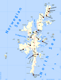
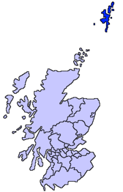
Shetland (formerly spelled Zetland, from Ȝetland) formerly called Hjaltland, is one of 32 council areas of Scotland. It is an archipelago to the north-east of Orkney and mainland Scotland, with a total area of approximately 1466 km². It forms part of the division between the Atlantic Ocean to the west and the North Sea to the east. The administrative centre and only burgh is Lerwick.
The largest island, known as the Mainland, is the third largest Scottish island and also the third largest island surrounding Great Britain. It has an area of 374 square miles.
Shetland is also a lieutenancy area, comprises the Shetland constituency of the Scottish Parliament, and was formerly a county.
Composition
Out of the approximately 100 islands, only fifteen are inhabited. The main island of the group is known as Mainland.
The other inhabited islands are: Bressay, Burra, Fetlar, Foula, Muckle Roe, Papa Stour, Trondra, Vaila, Unst, Whalsay, Yell in the main Shetland group, plus Fair Isle to the south, and Housay and Bruray in the Out Skerries to the east (see below).
Other , uninhabited, islands include:
- Balta, Bigga, Brother Isle
- East Linga
- Fish Holm
- Gloup Holm, Grunay, Gruney
- Haaf Gruney, Hascosay, Havra, Hildasay, Huney
- Lady's Holm, Lamba, Linga near Muckle Roe, Linga near Shetland Mainland, Linga near Yell, Little Roe, Lunna Holm
- Moul of Eswick, Mousa, Muckle Flugga, Muckle Ossa
- North Havra, Noss
- Orfasay, Out Stack, Oxna
- Papa, Papa Little
- Samphrey
- Sound Gruney, South Havra, South Isle of Gletness
- Urie Lingey, Uyea, Uynarey
- Vaila
- Vementry
- West Linga
Fair Isle lies approximately halfway between Shetland and Orkney, but it is administered as part of Shetland and is often counted as part of the island group. The Out Skerries lie east of the main group. Due to the islands' latitude, on clear winter nights the aurora borealis or 'northern lights' can sometimes be seen in the sky, while in summer there is almost perpetual daylight, a state of affairs known locally as the 'simmer dim'. Indeed, when standing at the highest point in the Isles, Ronas Hill (height 450m latitude 60° 32' 04"), the sun does not set at mid summer. In midwinter, by contrast, the sun does not fully rise.
| County of Zetland | |
| Geography | |
| Area - Total |
Ranked 15th 352,876 acres |
|---|---|
| County town | Lerwick |
| Chapman code | SHI |
 |
|
| ( In Detail) | ( Coat of Arms) |
| Motto Með lögum skal land byggja | |
| ( Old Norse: With laws land shall be built) | |
History
The old Gaelic name for Shetland (Innse Cat, "Islands of the Cat People") suggests that the original inhabitants were the same tribal group who inhabited Caithness ("Cat People's Headland") and Sutherland (Cataibh, "Cat People's Land"). Missionaries arrived around the 7th century and began converting the population to Christianity. Sometime in the 9th century, Shetland was invaded by the Norse and became a Norwegian colony for approximately 500 years, but ownership of Shetland, along with Orkney, defaulted to the crown of Scotland on 20 February 1472 following non-payment of the marriage dowry of Margaret of Denmark, queen of James III of Scotland. Subsequent attempts to make good on the debt and reclaim Shetland have been ignored, including the last bid in the early years of the twentieth century.
During World War II, boats from the Shetland Islands provided a relief service to occupied Norway, known as the " Shetland bus".
Norse names
The old Norse names of the principal islands were:
- Hjaltland (Mainland)
- Jell (Yell) - believed to be pre-Norse
- Unst - believed to be pre-Norse
- Fetlar - believed to be pre-Norse
- Hvalsey (Whalsay)
- Brusey (Bressay) - most likely named after a Norse nobleman Bruse
- Fugley (Foula) - literally bird's island
- Frjóey (Fair Isle) - Fertile island (Froøy/Fræøy in modern Norwegian)
Culture
The culture of Shetland is similar to that of Scandinavia. However, it also combines elements of Scottish culture as well.
Notable places
- Clickimin broch
- Fort Charlotte
- Jarlshof archaeological site
- Mavis Grind
- Mousa Broch
- Muness Castle the most northerly castle in the United Kingdom
- Old Scatness archaeological site
- Scalloway Castle
- Selivoe
- St Ninian's Isle
- Sullom Voe oil terminal
- Sumburgh Head
- Skaw the most northerly settlement in the United Kingdom
Economy
Traditionally, the economic activities of Shetland were primarily agricultural, especially the raising of Shetland sheep, known for their unusually fine wool, along with the Shetland Sheepdog as well as the Shetland pony. Crops raised include oats and barley; however, the cold, windswept islands make for a harsh environment for most plants. Crofting, the farming of small plots of land on a legally restricted tenancy basis, is still practiced and viewed as a key Shetland tradition as well as important source of income.
More recently, oil reserves discovered in the 20th century out to sea have provided a much needed alternative source of income for the islands. The East Shetland Basin is becoming one of Europe's largest oil fields. Oil produced there is landed at the Sullom Voe terminal in Shetland.
- Crude oil and Natural gas production
- Agriculture
- Aquaculture
- Fishing
Language
The Pictish language was replaced by Old Norse, which evolved into Norn, which was replaced by an insular dialect of Scots also known as Shetlandic, which in turn is being replaced by Scottish English. However, the legacy of Norn remains in the grammar and a number of words, making the Shetland dialect a distinctive form of Scots.
As Norn was gradually replaced by Scots, the original Scandinavian name of the islands, Hjaltland (hjalt in Old Norse meaning the hilt or pommel of a sword) became Ȝetland (the initial letter being the Middle Scots letter, yogh (which can also be found in the forename Menzies, e.g. Menzies Campbell.) This sounded almost identical to the original Norn sound, /hj/). When the letter yogh was discontinued, it was often replaced by the similar-looking letter ' z', hence Zetland, the mis pronounced form used to describe the pre- 1975 county council.
- ShetlandDictionary.com has been created for to help encourage the use of Shetlandic.
Transport
Transport between islands is mainly done by ferry.
Shetland is served by a domestic ferry connection to the mainland, operated by Northlink Ferries to
Lerwick also has an international ferry connection operated by Smyril Line to
- Tórshavn, Faroe Islands
- Seyðisfjörður, Iceland
- Bergen, Norway
- Hanstholm, Denmark
Schools
Anderson High School
Notable Shetlanders
- Arthur Anderson (1792-1868), co-founder of P&O
- Tom Anderson MBE (1910-1991), a fiddler, composer, folklorist and teacher who was a profoundly influential figure in the development of Shetland music
- Ian Bairnson (b. 1953), session guitarist ( The Alan Parsons Project)
- Aly Bain (b. 1946), fiddle player.
- Morgan Goodlad (b. 1950), controversial Chief Executive of Shetland Islands Council (see, for example, Private Eye No 1144 p27, or this story from the Sunday Herald.)
- Sir Herbert John Clifford Grierson (1866-1960), a literary scholar and critic
- Norman Lamont (b. 1942), Conservative MP, Chancellor of the Exchequer from 1990 to 1993.
- Steven Robertson, a theatre and film actor from Vidlin
- Robert Stout (1844 - 1930), Prime Minister of New Zealand on two occasions in the late 19th century
- Astrid Williamson, musician
- Sandra Voe (b. 1936), actress appearing in many small film and TV roles (including Coronation Street) and mother of Pulp keyboard player Candida Doyle.
- Neil Hughes from Seven Up!
Shetland Islands on film
Michael Powell made The Edge of the World in 1937. This film is a dramatisation based on the true story of the evacuation of the last thirty-six inhabitants of the remote island of St Kilda on 29 August 1930. St Kilda lies in the Atlantic Ocean, 64 kilometres west-northwest of North Uist in the Outer Hebrides; the inhabitants spoke Gaelic. Powell was unable to get permission to film on St. Kilda. Undaunted, he made the film over four months during the summer of 1936 on the island of Foula, in the Shetland Isles. Despite the fact that the Foula islanders speak the Norse-tinged dialect of Shetland, the film loses none of its power.
- The Edge of the World ( 1937) dramatizes the evacuation of the Islands and the ensuing tragedy.
- Return To The Edge Of The World ( 1978) was a documentary capturing a reunion of cast and crew of 1937's The Edge Of The World, 40 years after the fact, as they revisit the island.
- The Rugged Island: A Shetland Lyric (1934) at the Internet Movie Database
- Devil's Gate ( 2003).
- It's Nice Up North ( 2006) comedy documentary by Graham Fellows as John Shuttleworth.
Council political composition
- Independent - 17
- Liberal Democrats - 5
Shetland NHS
The Shetland NHS is the local Scottish health service in the Shetland Islands.

