Mount Kilimanjaro
2007 Schools Wikipedia Selection. Related subjects: African Geography
| Mount Kilimanjaro | |
|---|---|
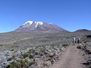 Kibo Summit of Kilimanjaro |
|
| Elevation | 5,895 metres (19,340 feet) |
| Location | Tanzania |
| Prominence | 5,885 m Ranked 4th |
| Coordinates | |
| Type | Stratovolcano |
| Last eruption | None in recorded history |
| First ascent | 1889 by Hans Meyer, Ludwig Purtscheller, Johannes Kinyala Lauwo |
| Easiest route | hike |
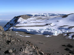
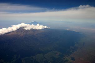
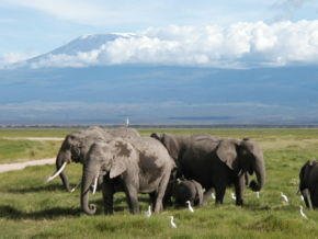
Kilimanjaro (or Kilima Njaro, which means "shining mountain" in Swahili), formerly Kaiser-Wilhelm-Spitze, is a mountain in northeastern Tanzania. Kilimanjaro is the tallest free-standing mountain rise in the world, rising 4600 meters (15,000 ft) from the base, and includes the highest peak in Africa at 5,895 meters (19,340 ft), providing the dramatic view from the surrounding plains. Kilimanjaro is a giant stratovolcano, not currently active, with fumaroles that emit gas in the crater on the main summit of Kibo. Scientists concluded in 2003 that molten magma is just 400 meters below the summit crater. Although new activity is not expected, there are fears the volcano may collapse, causing a major eruption similar to Mount St. Helens. Several collapses and landslides have occurred on Kibo in the past, one creating the area known as the western breach. Although there is no recorded history of eruptions, local legend speaks of activity around 170 years ago.
Description
The highest point is Uhuru Peak on the volcano Kibo, 5,895 metres. As the highest point in Africa, Uhuru Peak is one of the Seven Summits. The summit was first reached by the Marangu army scout, Johannes Kinyala Lauwo, who climbed it nine times before realising there was a crater. Lauwo served as a guide for the first ascent by nonindigenous climbers, German Hans Meyer and Austrian Ludwig Purtscheller, on October 6, 1889. Two other peaks are also extinct volcanoes: Mawenzi (5,149 metres), the third highest peak in Africa (after Mount Kenya) and Shira (3,962 m). Johannes' Notch is named after Lauwo. In 1989 Lauwo was presented with a house at Ashira Marangu by the West German government in recognition of his role on the Meyer expedition. His relative, Trilas Lauwo (1952- ) was the first Tanzanian woman to reach the summit via the Mweka route in 1972.
An ascent of Mawenzi requires rock climbing and/or snow/ice climbing skills. The climb to Uhuru Peak is considered to be a relatively straightforward endeavour; however, ample time must still be provided for proper acclimatization to prevent altitude sickness. The three easiest routes, Marangu, Rongai and Machame can be climbed by a person of good health, and require no mountaineering experience. Many who climb employ altitude-sickness medication and find this to be helpful in preventing the pounding headaches that plague many travellers. Those who travel on the Marangu route usually take 4-5 days to complete their climb. Huts with cooking facilites, bathrooms, and (sometimes) electricity are available at the end of each day's journey. The final part of the climb, from Kibo hut at 15,500 ft. to the summit, is generally undertaken at night, because the scree is frozen together, making the climb significantly easier. Gilman's Point, on the rim of the crater, but about 1½ hours hike from Uhuru, is attained at 5:00 - 6:00 am; those who have the strength to continue may then hike on to Uhuru in the growing sunlight and rising temperatures. Another route is the Western Breach, which is much more technical in nature. Annually, approximately 15,000 people attempt to climb the mountain, of whom 40% reach the summit.
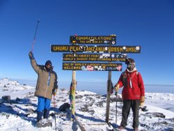
At the summit, there is a sign posted by the Tanzanian government. The sign (printed in English only) reads "Congratulations! You are now at Uhuru Peak, Tanzania, 5,895 m. AMSL. Africa's Highest Point. World's Highest Free-Standing Mountain. One of World's Largest Volcanos. Welcome." The sign is covered in travel stickers from past trekkers who have left their mark on the top of the peak. Near this famous sign is a box containing a log that many climbers have signed.
Due to the equatorial location as well as huge height, climbers can experience almost every climate type on earth during the journey to the top.
Kilimanjaro is also the highest point in the world to be covered by a GSM mobile phone network. The service is provided by Vodacom.
Current conditions
While the volcano appears to be dormant on the inside, events on top of the mountain have been drawing global attention recently. The glaciers that have covered the top of the mountain for the past 11,700 years are rapidly disappearing. Over the past century, the ice cap volume has dropped by more than 80% . In 2002, a study led by Ohio State University ice core paleoclimatologist Lonnie Thompson predicted that ice on top of Africa's tallest peak would be gone between 2015 and 2020 . In March 2005, it was reported that the peak was now almost bare for the first time in 11,000 years . A comparison of ice core records from Kilimanjaro suggests that conditions similar to those of today have not existed since then. Though the cause of the reduction in ice volume is in dispute, the loss of the Kilimanjaro ice fields will carry significant climatological and hydrological implications for local populations who depend on water from the ice fields during the dry seasons and monsoon failures.
As of January 2006, the Western Breach route has been closed by the Tanzanian government following a rockslide which killed four people at Arrow Glacier Camp. The rockslide is believed to have been caused by frost action in an area which is no longer permanently frozen.
After the Western Breach route was closed in January 2006, many expeditions that had intended to use this route have instead used the Lemosho/Barafu route. As the Western Breach route, this route starts to the west and goes up the Shira Ridge towards Lava Tower. Instead of going up to Arrow Glacier camp and the breach, however, this route goes around the southern edge of Kili towards Barafu camp. From Barafu Camp, around 15,200 altitude, a nighttime summit attempt is usually attempted.
Climbing routes
There are several routes officially sanctioned for climbing Kilimanjaro. These are:
- Machame
- Marangu
- Rongai
- Lemosho
- Umbwe
- Mweka (descent only)
Machame route
The Machame route as of 2006 is described here. The route is typically done on a 6 or 7 day hike.
The campsites and gates (with corresponding elevations) are as follows:
- Machame Gate (start of trek) (5718 ft/1738 m)
- Machame (9927 ft/3018 m)
- Shira (12355 ft/3756 m)
- Barranco (13066 ft/3972 m)
- Karanga (optional camp, used by 6-day climbers)
- Barafu (high camp before summit) (15239 ft/4633 m)
- Mweka (descent) (10204 ft/3102 m)
- Mweka Gate (end of trek) (5423 ft/1649 m)
(The given altitudes are sourced from a GPS device and are accurate to a few hundred feet.)
One benefit of the Machame route is its quick rise to relatively high elevations (~10000 ft, or ~3040 metres), and a short ascent to the Lava Tower site (~15,000 ft/~4560 m) before descending back to Barranco Camp (12,700 ft) on the same day. This follows the climber's adage 'climb high, sleep low', and helps altitude acclimation. The initial steep ascent also helps climbers acclimate.
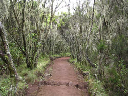
The Machame route starts from Machame Gate and travels upwards through the montane rainforest, characterized by dense vegetation, a muddy trail and short sections of steep climbs. The first campsite, Machame Camp, is right after the dense tree cover in an area with lower but still thick bushlands.
The second day continues through increasingly sparse trees and bushes into moorlands. Picturesque hanging mosses often cover trees and offer an ethereal quality to the landscape. The day finishes with Shira Camp, which is on a small plateau in the high moorlands, and features views of Kibo in the northwest and Mount Meru towards the east. White necked ravens can be seen throughout the day. There is also a set of small caves a short walk from the campsite known as the Shira Caves.
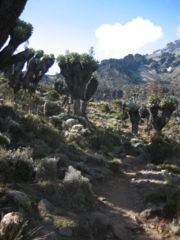
The third day starts in the moorlands and moves into alpine desert, with less trees and more rocks. The highest point is the base of the Lava Tower, after which the trail descends into the Barranco Valley. More vegetation is present in this zone, especially the area just before the campsite. This area is called the 'Garden of the Senecias' which features many of the huge senecia plants. Shorter lobelia plants are also present.
The fourth day starts with the ascent of the Barranco Wall, which is considered a scramble in climbing terms. The top of the Wall has attractive vistas of Kibo and the surrounding landscape. The trail continues with many up and down sections across small streams and rivulets, and finally crosses the Karanga River to the Karanga campsite.
The fifth day follows the path up and across a rocky zone, finishing at the high camp Barafu. Very little vegetation can be found on the inhospitable terrain. A field of sedimentary rocks litters the ground like many broken mirrors. (Note - the 6 day trek omits the Karanga campsite, and climbers continue directly to Barafu on the same day)
The summit is usually attempted on the very early morning of the 6th day (around midnight). Barafu is also used as a summit campsite for the Umbwe route. Climbers typically take somewhere between 5-7 hours to ascend, using headlamps and cold weather gear. The first milestone is Stella Point (18652 ft/5685 m), which is on the crater rim. Following Stella Point, the trail continues for another 30 mins to the summit - Uhuru Peak.
The descent back to Barafu takes roughly 4 hours. Some climbers ' scree slide' down the slope, which entails skidding/running down the loose gravel at medium speed. From Barafu, climbers typically take a short break, and continue downwards through the alpine desert and ensuing moorlands to Mweka Camp.
The 7th and final day has trekkers continue through the montane forest to Mweka Gate. Troops of black-and-white colobus monkeys can often be seen in the dense growth.
A travelogue of the Machame route can be viewed here.
In the arts
- Mount Kilimanjaro was the inspiration and backdrop for Ernest Hemingway's classic short story The Snows of Kilimanjaro (1936). He also wrote a non-fiction account of his safari experiences in the 1950's, posthumously published as Under Kilimanjaro (2005).
- Mount Kilimanjaro is refered to in one of Monty Python's Flying Circus skits, Double Vision. Sir George Head ( John Cleese) unwittingly proclams "I'm leading this expedition and we're going to climb both peaks of Mount Kilimanjaro" before Bob ( Eric Idle) points out that there is only one peak.
- Mount Kilimanjaro is mentioned in Toto's 1982 hit, " Africa" ("I know that I must do what's right, sure as Kilimanjaro rises like Olympus above the Serengeti").
- Mount Kilimanjaro is shown as the dramatic backdrop to the animal realm of Disney's The Lion King.
