Mendip Hills
2007 Schools Wikipedia Selection. Related subjects: Geography of Great Britain
|
Map sources for Mendip Hills at grid reference ST481550
|
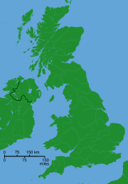
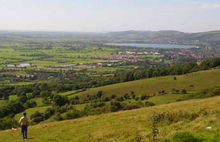
The Mendip Hills are a range of limestone hills ( karst) situated to the south of Bristol and Bath in north Somerset, England. The hills are bounded by the Somerset Levels in the south and west, and the River Avon and Chew Valley Lake in the north. The hills give their name to the roughly analogous local government district of Mendip, but some of the northern slopes are located in the bordering Unitary Authorities of North Somerset and Bath and North East Somerset, part of the former County of Avon which was dissolved in 1996.
200 km² of the Mendips are an Area of Outstanding Natural Beauty, a designation which gives the area the same level of protection as a national park.The Mendip Hills AONB Service and visitor centre is at the Charterhouse Centre near Blagdon.
Etymology
The name Mendips is probably derived from the mediaeval term "Myne-deepes".
An alternative explanation is that the name is cognate with Mened (Welsh mynydd), a Brythonic term for upland moorland. The suffix may be a contraction of the Anglo-Saxon hop meaning a valley.
Government and politics
Many of the villages in the valley have their own parish councils which have some responsibility for local issues. They also elect councillors to district councils e.g. Mendip or Sedgemoor and Somerset County Council or unitary authorities e.g. Bath and North East Somerset, which have wider responsibilities for services such as education, refuse, tourism etc.
Each of the villages is also part of a constituency, either Wells (UK Parliament constituency) or Wansdyke (which will become North East Somerset), each of which elects one MP to the Westminster Parliament. The area is also part of the South West England (European Parliament constituency) which elects seven members to the European Parliament. Avon and Somerset Constabulary provides police services to the area.
Geology
The Mendip Hills are the most southerly Carboniferous Limestone Upland in Britain and are comprised of three major anticlinal structures, each with a core of older Devonian sandstone and Silurian volcanic rocks. The latter are quarried for use in road construction and as a concrete aggregate.
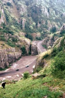
The response of the limestone to weathering has resulted in a range of surface features, including gorges, dry valleys, screes and dolines. These are complemented underground by a large number of caves, including Wookey Hole both beneath the plateau and at the base of the southern escarpment. There are also limestone pavements, and a number of gorges, most famously Cheddar Gorge and Burrington Combe. Springs, a number of which deposit tufa, are a particular feature of the eastern part of the hills.
The Devonian and Silurian rocks are generally more resistant to weathering and form some of the highest points on the hills. The highest point of the Mendip Hills is Beacon Batch on Black Down at 325 metres (1068 feet) above sea level. Black Down is of a moorland characteristic, with its steeper slopes covered in bracken and its flatter summit in heather and grasses rather than the pastureland which covers much of the plateau. In the Second World War, a bombing decoy was constructed on top of Black Down, and piles of stones (known as a cairn) were created to prevent enemy aircraft using the hilltop as a landing site. Other high points include Bleadon Hill and North Hill near Priddy.
In some areas the Carobiniferous Limestone and the Dolomitic Conglomerate have been mineralised with lead and zinc ores. From the time of the Romans until the late Victorian era, the hills were an important source of lead. These areas have been the subject of a major mining industry in the past and this is reflected in areas of contaminated rough ground known locally as ‘Gruffy’. The word "gruffy" is thought to derive from the grooves that were formed where the lead ore was extracted from veins near the surface.
Ecology
There are three nationally important semi-natural habitats which are characteristic of the area: Ash-Maple woodland (often with abundant small-leafed lime), Calcareous grassland and Mesotrophic grassland.
Much of the Mendip Hills is open calcareous grassland which supports a large variety of wild flowering plants and insects. Grazing by rabbits, sheep and cattle maintains the grassland habitat. Some of the area is native deciduous woodland.
Some of the area has been used intensively for arable agriculture, particularly since World War I. Some of this land is now being returned to grassland as the demand for arable land in Britain declines, but the use of fertilisers and herbicides have reduced the biodiversity in these areas.
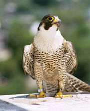
Many bird species can also be found. Of particular significance is the Peregrine Falcon which has gradually recolonised the Mendips over the last 20 years. It breeds on sea and inland cliffs and also on the faces of both active and disused quarries. The upland heaths of the west Mendips have recently increased in ornithological importance, due to colonisation by the Dartford Warbler, which can be found for example at Black Down and Crook Peak. In Britain, this species is usually associated with lowland heath. The woodlands at Stock Hill are a breeding site for Nightjar and Long-eared Owl.
The Waldegrave Pool, part of Priddy Mineries is an important site for dragonflies, including Downy Emerald (the only Mendip breeding site for this species) and Four-spotted Chaser.
A range of important small mammals are found in the area including the Dormouse which is restricted largely to coppice woodland and scrub, Bats including the nationally rare lesser and Greater Horseshoe Bats (Rhinolophus ferrumequinum) which have a number of colonies in buildings, caves and mines in the area.. A rare and endangered species, the greater horseshoe bat is protected under the Wildlife and Countryside Act 1981 and is listed in Annex II of the 1992 European Community Habitats Directive.
Amphibians such as the Great crested newt have a wide distribution across Mendip and is often found in flooded disused quarries.
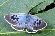
Several rare butterflies are also indigenousto the area. The Large blue butterfly became extinct in the late 1970s since when a research project has been undertaken into its ecology and reintroduction. A successful reintroduction has been made to a calcareous grassland in the Mendips. Other species include the nationally scarce Pearl-bordered Fritillary, Duke of Burgandy and White-letter Hairstreak.
The White-clawed crayfish is also nationally rare and a declining species with a small population in a tributary of the Mells river.
A well known Mendip feature is the dry stone walls which fragment the pasture into fields. Constructed from local limestone and in an "A frame" design, the walls are strong yet contain no mortar. Unfortunately years of neglect are allowing many walls to disintegrate, being replaced or contained by a mix of barbed wire and sheep fencing. These dry-stone walls are of botanical importance, supporting important populations of the nationally scarce Wall Whitlow-grass. Amongst the plants which occur in the area are the Cheddar pink, Purple gromwell, White rock-rose, Somerset hair-grass and Starved wood-sedge.
Climate
Along with the rest of South West England, the Mendip Hills has a temperate climate which is generally wetter and milder than the rest of England. The annual mean temperature is approximately 10oC and shows a seasonal and a diurnal variation, but due to the modifying effect of the sea the range is less than in most other parts of the UK. January is the coldest month with mean minimum temperatures between 1°C and 2°C. July and August are the warmest months in the region with mean daily maxima around 21°C. The number of hours of bright sunshine is controlled by the length of day and by cloudiness. In general December is the dullest month and June the sunniest. The south-west of England has a favoured location with respect to the Azores high pressure when it extends its influence north-eastwards towards the UK, particularly in summer. Convective cloud often forms inland, especially near hills, and acts to reduce sunshine amounts. The average annual sunshine totals around 1600 hours. Rainfall tends to be associated with Atlantic depressions or with convection. The Atlantic depressions are more vigorous in autumn and winter and most of the rain which falls in those seasons in the south-west is from this source. In summer, convection caused by solar surface heating sometimes forms shower clouds and a large proportion of rainfall falls from showers and thunderstorms at this time of year. Average rainfall is around 800-900 mm. About 8-15 days of snowfall is typical. November to March have the highest mean wind speeds, with June to August having the lightest winds. The predominant wind direction is from the South West.
History
The area contains many neolithic, iron age and bronze age remains, including barrows and forts. There is good evidence for 286 definite examples of round barrows within the AONB. The caves of Cheddar Gorge in particular have preserved much archaeology as flood waters have washed artifacts into the caves and preserved them in silt. The Cheddar Man was found here.
Throughout history settlement on the Mendip Hills appears to fall into two types. The first, apparent in the neolithic and bronze age periods and repeated on a small scale in the medieval and post-medieval farms, comprised occupation by self-sufficient groups in small communities or isolated farms. The second was represented in the iron age and roman periods by large sites with specialist functions, existing by virtue of their ability to exert power over lowland producers. From the iron age onward the ownership of land would have been of increasing importance with large landholdings based on the mines or on stock grazing, denying settlers access to the plateau or perhaps, at times, forcing them off the hills.
There is evidence of mining on the mendips back into the late bronze age when there were technological changes in metal working indicating the use of lead. The roman invasion, and possibly the preceding period of involvement in the internal affairs of the south of England, was inspired in part by the potential of the Mendips. A great deal of the attraction of the lead mines may have been the potential for the extraction of silver. The EX ARG VEB stamps on the Mendip lead pigs specify a desilvering process and cast silver ingots have been found. The silver coinage of the Dobunni and Durotriges is likely to reflect the availability of silver from the mines. The earliest documented reference is for the Charterhouse mines in 1189. By the end of the medieval period a complex body of customary law had come into existence dealing with the four "Mendip mineries". That medieval control was in the hands of the monastic foundations may indicate some continuity of tenure of large scale holdings, focused on the mines, from the Roman period.
In recent centuries the hills, like the Cotswolds to the north, have been quarried for stone to build the cities of Bath and Bristol, as well as smaller towns in Somerset. Whatley Quarry and Torr Works approximately mark the eastern end of the Mendips and are major suppliers of roadstone to south-east England. A large proportion of the stone is moved by rail company Mendip Rail.
The Mendip Hills is home to the Mendip UHF television transmitter installed in the 1960s, the tallest mast in the region situated on Pen Hill near Wells.
Since 2003 arguments have raged over plans to erect a 300 foot Wind Turbine on the Mendip Hills near Chewton Mendip. After months of debate, the proposal was rejected by Mendip District Council supported by a range of local groups and organisations. The key arguments for rejection was that the proposed location for the turbine was on the edge of the Area of Outstanding Natural Beauty, that the environmental impact and amount electricity generated would be nominal and that it would be a terrible eyesore in such a stunning environment. In April 2006 a planning enquiry gave Ecotricity permission to build a 335 foot (102m) turbine during the next year.
Sport and leisure
The Mendips are home to a wide range of outdoor sports and leisure activities. The particular geology makes it a national centre for caving and cave diving, in addition to climbing and abseiling. The rich variety of fauna and flora also makes it attractive for Hillwalking and those interested in natural history.
The Mendip Gliding Club is based at Halesland Airfield near Priddy.
Mendip raceway is a venue for stock-car racing near Shipham.
It is also home to several festivals including the Big Green Gathering, folk festival and sheep fair in Priddy and a proposed music festival at Chewton Mendip.
Notable towns
- Cheddar
- Shepton Mallet
- Wells
