Lake Titicaca
2007 Schools Wikipedia Selection. Related subjects: Central & South American Geography
| Lake Titicaca | |
|---|---|
|
|
|
| Coordinates | |
| Lake type | Mountain Lake |
| Primary sources | 25 rivers |
| Primary outflows | Desaguadero River Evaporation |
| Catchment area | 58,000 km² |
| Basin countries | Peru Bolivia |
| Max-length | 190 km |
| Max-width | 80 km |
| Surface area | 8,372 km² |
| Average depth | 107m |
| Max-depth | 281m |
| Water volume | 893 km³ |
| Shore length1 | 1,125 km |
| Surface elevation | 3,812 m |
| Islands | 42+ islands See Article |
| Settlements | Puno, Peru Copacabana, Bolivia |
| 1 Shore length is an imprecise measure which may not be standardized for this article. | |
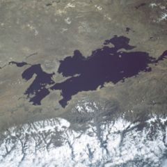
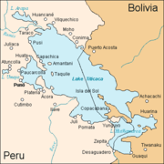
Lake Titicaca is the highest commercially navigable lake in the world , at 3,812 m (12,507 feet) above sea level. Located in the Altiplano high in the Andes on the border of Peru and Bolivia, at 16°S 69°W, Titicaca has an average depth of 107 m , and a maximum depth of 281 m. The western part of the lake belongs to the Puno Region of Peru, and the eastern side is located in the Bolivian La Paz Department.
More than 25 rivers empty into Titicaca, and the lake has 41 islands, some of which are densely populated.
Titicaca is fed by rainfall and meltwater from glaciers on the sierras that abut the Altiplano. It is drained by the Desaguadero River, which flows south through Bolivia to Lake Poopó. This accounts for less than five per cent of the lake's water loss, however, the rest is caused by evaporation as a result of the strong winds and sunlight at this altitude.
Islands
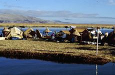
Uros
Titicaca is notable for a population of people who live on the Uros, a group of about 43 artificial islands made of floating reeds. These islands have become a major tourist attraction for Peru, drawing excursions from the lakeside city of Puno.
Taquile
The people of Taquile, off the coast from Puno, are known for their fine handwoven textile products, among the highest quality in Peru. The island attracts many tourists each year.
Amantaní
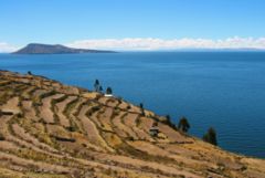
Amantaní is another small island in Lake Titicaca populated by Quechua speakers. About 800 families live in six villages on the basically circular 15-square kilometer island. There are two mountain peaks, called Pachatata (Father Earth) and Pachamama (Mother Earth), and ancient ruins on the top of both peaks. The hillsides that rise up from the lake are terraced and planted with wheat, potatoes, and vegetables. Most of the small fields are worked by hand. Long stone fences divide the fields, and cattle, sheep, and alpacas graze on the hillsides.
There are no cars on the island, and no hotels. A few small stores sell basic goods, and there is a health clinic and school. Electricity is produced by a generator and limited to a couple of hours each day.
Some of the families on Amantaní offer a meal or overnight stay to tourists, arranged through tour guides. Guests typically take food staples (cooking oil, rice, sugar) as a gift.
Isla Del Sol
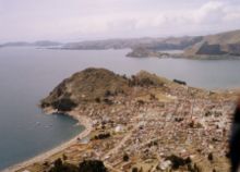
Situated on the Bolivian side of the lake with regular boat links to the Bolivian town of Copacabana, Isla del Sol ("Island of the Sun") is one of the lake's largest islands. It is the site of several important Inca ruins and its economy is mainly driven by tourism revenues. Subsistence agriculture and fishing are widely practised.
Name
The origin of the name Titicaca is unknown. It has been translated as "Rock Puma", allegedly because of its resemblance to the shape of a puma hunting a rabbit, combining words from the local languages Quechua and Aymara, and as "Crag of Lead". Locally, the lake goes by several names. It is widely made fun of and giggled about for the reason that it says, if interpreted that way, "naughty" words.
Because the southeast quarter of the lake is separate from the main body (connected only by the Strait of Tiquina), the Bolivians call it Lago Huiñaymarca and the larger part Lago Chucuito. In Peru, these smaller and larger parts are referred to as Lago Pequeño and Lago Grande, respectively.
Trivia
The Bolivian Naval Force uses the lake to carry out naval exercises, maintaining an active navy despite being landlocked.
The partly-salt Lake Maracaibo in Venezuela is bigger than Titicaca, at about 13,000 square kilometres, but some say it should be classified as a sea because it is connected to the ocean.
